

The United States rejects the new world map as ideological
BY PETER SESAY
With a vote of 164 nations in support, one dissent, and six abstentions, the U.N. General Assembly on Friday passed a resolution termed “Correct the Map” to adopt a new world map that more accurately depicts the size of countries and continents. The only dissenting nation was that very one that took the lead in the creation of the world organization during World War II and hosts it on its territory: the United States of America.
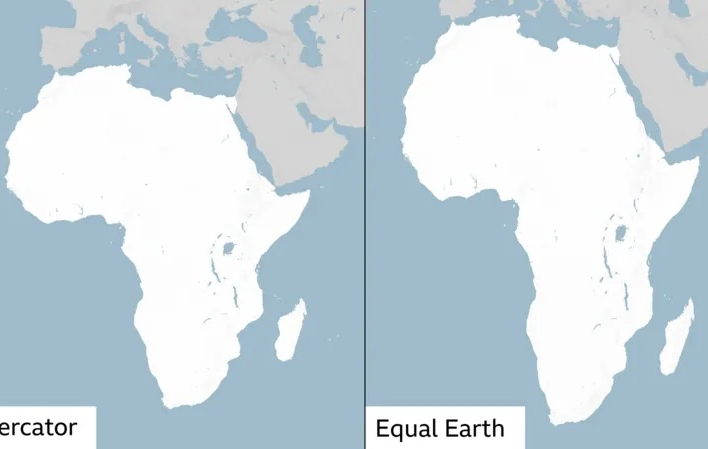
The resolution was sponsored by the tiny West African nation of Togo, obviously with the support of a nation that has a say in world affairs, France. The old map, The Mercator map, was developed in 1569 by the Flemish cartographer Gerardus Mercator to help European explorers navigate across the world. It was often criticized, among other examples, for showing Africa as being similar in size to Greenland when, in fact, the Black continent is 14 times larger. As #CorrectTheMap, an online campaign group for the map change, put it about the new map: “You could fit the United States, China, India, Japan, Mexico and much of Europe into Africa and still have land to spare.” To remedy the inaccuracy of the old map, in 2018, a team of cartographers created the new map called The Equal Earth map, which the African Union adopted in February of this year. It was about time!
Addressing the press ahead of the vote on Friday, Togolese Foreign Affairs Minister Robert Dussey pointed out the “scientific” nature of the map change, adding, “A fair world begins with a fair map.” But that’s not how Yaryna Ferencevych, a U.S. representative to the United Nations, felt, saying in a statement, “While this initiative is presented as an anodyne effort to update cartographic proportions, the United States clearly sees it cannot be separated from the much larger and more radical ideological project it belongs to.”
Her fellow-countryman, Tom Patterson, a retired cartographer for the U.S. National Park Service, a co-creator of the Equal Earth map, could not disagree more.
In an interview with National Public Radio, Patterson said of the old map: “That was extremely useful during the age of exploration and European colonialism. If you’re using the Mercator map as a world map, say, in the classroom, students would just have a completely warped view of the size of countries in the world.”
For his part, following the passage of the “Correct the map” resolution, Foreign Minister Robert Dussey said, “Correcting the map means restoring to continents in the mind of people the reality of the true dimensions. […] The way people see you shapes the kind of relationship they develop with you, and that relationship determines the nature of our partnerships.” The Togolese top diplomat also said: “It raises a broader question of equity in how the world is represented and neglected.”
Freelance correspondent Yussef Baba in New York contributed to this report.


Soumanou Salifou (administrator)
Soumanou is the Founder, Publisher, and CEO of The African Maganize, which is available both in print and online. Pick up a copy today!